
by Mish
As mandatory evacuations continued for a second day, San Jose officials said Wednesday they could still not provide a timetable for when thousands of residents would be allowed to return after the city was hit by what officials described as the worst flooding in 100 years.
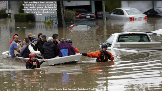
[San Jose Mayor Sam Liccardo] vowed a full investigation into why there was not more warning before the floodwater hit the center of the city, saying many residents were caught off guard.
“If the first time a resident is aware that they need to get out of a home is when they see a firefighter in a boat, then clearly there has been a failure,” he said.
The mandatory evacuation zone largely encompasses a big swath of central San Jose, extending just east of San Jose State University and two miles east of Norman Y. Mineta San Jose International Airport, Vossbrink said. At its widest point, the mandatory evacuation area covers a zone roughly two miles long and one mile wide.
Evacuation advisories were also issued to 36,000 residents. The larger voluntary evacuation advisory zone covered a business and industrial area, a roughly seven-mile stretch of Coyote Creek. The zone went from Interstate 280 northward, beyond U.S. 101, Interstate 880, and all the way to Highway 237 near San Francisco Bay.
The district’s chief operating officer, Jim Fiedler, said he believes the water will subside by Wednesday afternoon. Crews have repaired a damaged levee that allowed water to flow onto U.S. 101 Tuesday, forcing its closure. The freeway has since been reopened.
At Least 8 Dead in California Floods
Weather.com reports At Least 8 Dead in California Floods.
Flood Mapping
SF Curbed has a nice map and pictures of 18 affected areas in its report California storm floods: Mapping the impact across Northern California.

Just one of several RVs washed away by overflowing #RussianRiver in #Forestville pic.twitter.com/2jugFctXzO
— Laura Anthony (@LauraAnthony7) January 9, 2017
The mostly-evacuated River Bend RV park in #Forestville That’s #PaulBunyan out there standing his ground. #RussianRiverflooding pic.twitter.com/Oy2kANazPb
— Laura Anthony (@LauraAnthony7) January 9, 2017
#SonomaCounty floods: #RussianRiver turns vineyards along River Road into lakes, headed to #Guerneville #KTVU pic.twitter.com/J6fa3eo0s2
— Debora Villalon (@DeboraKTVU) January 9, 2017
Tent cabins in #Yosemite‘s Half Dome Village in flood waters below Glacier Point.https://t.co/9VBeg63Gc3 Bee Photo Silvia Flores #CaStorm pic.twitter.com/KXPbm2Rq5X
— Fresno Bee (@FresnoBee) January 10, 2017
The Yuba River is raging today after the weekend rain. Sacto Weir due to open to prevent floods in downtown Sacto: https://t.co/ReU1Kp9fJH pic.twitter.com/yn0UZcKoBP
— KFBK News Radio (@kfbk) January 10, 2017
For now, the potential breach of the levee is the greatest concern https://t.co/LmSGKRwYFi
— Fresno Bee (@FresnoBee) February 22, 2017
As my friend Mark commented, “It will not be too long before someone erroneously chimes in how the flooding will add to GDP”.
Avoid Global Warming Nonsense
The global warming advocates will no doubt blame both the flood and the preceding drought on global warming.
Thinking individuals will place the blame on variances in El Niño and La Niñaevents.
On June 26, 2016, Science News For Students reported Last year’s strong El Niño is gone. Next up: La Niña.
Every few years, the world’s weather is thrown off balance. It happens when surface waters near the equator in the eastern and central Pacific Ocean warm up just a fraction of a degree. Afterward, some regions experience heavier rainfall than normal — and flooding. Others will battle drought and wildfires. Still others might have to contend with ice storms and other extreme weather. This pattern of disruption is known as an El Niño (El-NEEN-yo). (The name is Spanish for “the boy.”)
El Niño has a “sibling.” It’s a different weather effect called La Niña (Lah-NEEN-yah). It develops when waters near the equator in the eastern Pacific cool down. And NOAA now estimates that there is a 75 percent chance that La Niña will take over in the coming months. La Niña can cause droughts in South America and heavy rainfall in Southeast Asia. It also can make hurricane seasons in the Atlantic Ocean more intense. Stay tuned.
Here is an amusing prediction from May 13, 2016: ThanksEl Niño, But California’s Drought Is Probably Forever.
Mike “Mish” Shedlock