
Fire Tornadoes, Fire Clouds, Crown Fires
USA Today explains Fire Tornadoes, Fire Clouds, Crown Fires
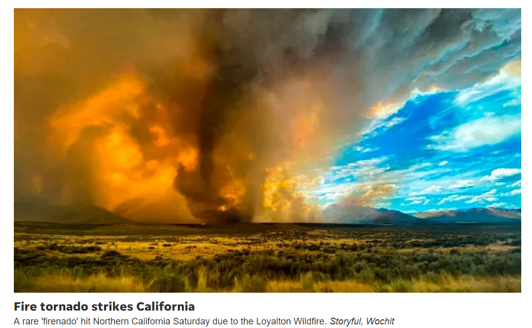
Fire Tornadoes and Whirls
Fire tornadoes are generated when intense heat from a wildfire causes hot air to rush up from the ground.
As air comes in it sometimes starts to rotate. The Great Chicago Fire in 1871, one of the most devastating in American history, was exacerbated by fire whirls.
Crown Fires
Running fires are when fires accelerate at a rate faster that can be controlled. Crown fires take place when fires climb a tree; they usually spread below the tree line before making their way upward.
“You can almost watch tree to tree burn in a matter of seconds from each other and you’ll see this gigantic flame wall spreading on the tops of trees,” said Heath Hockenberry, the National Weather Service’s national fire weather program manager.
Pyrocumulus Fire Clouds
Pyrocumulus clouds – essentially “fire clouds” form over heat sources. The bushfires that ravaged Australia earlier this year featured the massive clouds.
“They’re very concerning for firefighters because they cause their own storm,” said Hockenberry.
Mojave National Preserve Goes Up in Flames

Here is a very emotional video.
A firefighter was in tears as Joshua Trees burnt to the ground.
I am very familiar with Joshua Tree National Park and was nearly in tears myself.
Areas of Raging Fires

Red tones mark fire perimeters. Orange tones are areas were evacuation orders are in place.
Fire Evacuation in Napa and Sonoma Counties
Mercury News reports California Wine Country Evacuations.
The LNU Lightning Complex fires have forced evacuations of a large part of Napa, Solano and Sonoma counties, as well as portions of Lake and Yolo.
As of Saturday morning, fires had burned 314,207 acres (490 square miles) and had destroyed 560 structures, according to the Sonoma-Lake-Napa unit of the California Department of Forestry and Fire Protection. Containment was estimated at 15%.
US Fire Location Map

The above map from the Cal-Fire Evac Viewer
You may also wish to try the New York Times California Fires Map Tracker.
Big Basin Redwoods State Park Headquarters

119,000 Evacuees and 900,000 Acres Torched
The New York Times reports 119,000 Evacuees as Blazes Spread.
Firefighters are struggling to get a handle on the 560 wildfires that are spreading rapidly throughout California, torching more than 900,000 acres of land and forcing more than 119,000 people to flee their homes.
Despite the 12,000 firefighters currently battling the blazes, about a dozen major fires continue to grow, particularly in Northern California, where two fire groupings are now some of the largest in the state’s history.
Lightning Siege
Even as the fires grow further, forecasters with the National Weather Service’s Bay Area office warned that there could be more dry thunderstorms this weekend, potentially bringing a dangerous combination of lightning and wind to an already-burning region. Many of the current fires were ignited during an extraordinary period of more than 12,000 lightning strikes last weekend, what fire officials have called a “lightning siege.” They have now burned a size of land larger than Rhode Island.
Entire University of California, Santa Cruz Campus
The C.Z.U. Lightning Complex has led fire officials to order 77,000 people in San Mateo and Santa Cruz Counties to evacuate, including the entire University of California, Santa Cruz, campus. That group of fires has grown to 63,000 acres, consumed almost 100 buildings and is 5 percent contained.
Redwood Trees Big Basin State Park

Governor Asks Australia and Canada for Help
The BBC reports California Governor Asks Australia for Help.
Help was on its way from several US states as Gov Newsom put in a plea for assistance from Australia and Canada.
“These fires are stretching our resources, our personnel,” he said.
Calfire Update – Lightning Storm Monday and Tuesday
The Wall Street Journal reports California Wildfires Continue to Rage Across State
Nearly 14,000 homes, with a total estimated value of $9.6 billion, were at risk of destruction across northern California, with the Vallejo-Fairfield metro area being the most affected, according to an analysis by Realtor.com published Friday. News Corp, parent of The Wall Street Journal, operates Realtor.com.
Home Burned in Vacaville

Flying Embers

The above two images are 2 of 27 from the WSJ.
Hoping for Rain
Best wishes to all impacted.
I keep watching the forecasts hoping for rain but the maps still show none is expected.
Mish


Oh Sweet Saint of San Andreas, hear my prayer.
Here are some photos from Thursday when I did a hike in the Montara/Pacifica area. You can see the fire clouds to the south in a couple of them. I’ll be heading back out that way on Sunday.
Well, that one didn’t work
But try NWS SAFER–it has choices for maps of fire, flood and hurricanes—pick your calamity of the moment.
Inciweb has excellent maps of the fires
Incredible image–2 hurricanes for NOLA
I saw blue sky to the west today. Praying for all. There is a huge tropical storm dragging humidity in but the air is so dry it doesn’t rain. When it does rain there are going to be landslides and mudslides. It is the strangest weather pattern for mid August I can recall in my 11 years out here.
Wont rain for another couple months in my part of ca.
California is a perfect example of what the results of Democratic policies create. Ask yourself why people are fleeing every Democratic controlled city and state and then ask yourself why the hell we would want to implement those policies nation wide.
If the Democrat environmentalists had listened to the firefighters 30 yrs ago, the state would not be burning now…..
Wasn’t San Jose the city with the highest number of new apartment construction? I wonder how long the lumber prices are going be flying high? $830.90 on close Friday. First it was Trump’s tariffs on Canadian lumber, then it was covid shutting of the lumber supply and China shut down plywood production. Now we have a major fire that will bump demand up higher. Then there is the insurance companies. Rebuild is going to be a big problem. https://www.youtube.com/watch?v=bXsHGj8AMPQ
I’ve seen many a sunset among the Joshua trees. Desert landscapes grow so slowly. It’s unlikely it will recover in our lifetimes. Glad I got to see it.
we are all living in a Petri dish on top of a ever hotter Bunsen burner
… and the ants have found our dish
Apparently this was reversed today but as of yesterday this was Trump’s response.
What wasn’t reversed is that Trump is a moron. The Dunning-Kruger effect should be renamed the Trump effect. Too stupid to know he’s stupid. Thinks he is the greatest expert on everything.
Sad. Terrible. I’ve spent happy times in just about every locale you mentioned. I don’t know what to say….
Yea no such thing as global warming.
Am I missing something. California asking help from Canada and Australia. What about Washington? Does the Federal government have no capacity to help or is Trump happy letting it burn since it supports Biden. There was earlier reporting that Trump thinks like this.
Where is Washington on this?
Trump is getting rid of the D mailboxes.
Washington had it’s feelings hurt, and doesn’t want to help.
GO CLEANUP THE DEAD LEAVES! [lol]
Trump thinks its a hoax, like corona virus!
Not sure if lightning making charcoal can be changed into carbon making lightning.
I wouldn’t mind if Trump gets reelected and allows California to secede from the union. 1/6 to 1/7 of the US economy goes with it and California becomes the 6th largest economy on the planet and gets to keep 100% of its federal tax revenue.
…and goes bankrupt
When I was a kid in California we used to do extensive controlled burns as soon as the brush was dry enough to burn unless the cattle and sheep could graze it down, a practice possibly learned from the native americans who used to control burn all over the southwest. Was just up in the northwest corner of Angeles national forest, absolutely loaded with fuel, at least 30 years worth. One spark and would be a raging fire.